- Today Wintry Mix Storm, Big Snow Dawg Barking Thursday??
- Winter Storm #4 and #5, Earth’s Rumbling
- Ice Ice baby verifies, Saddle Up Cowboys and Girls – YEEHAW!! USAID Really?
- Thursday Winter Storm, Pattern is ABSOLUTLETY LOADED – SUPER BOWL STORM
- Clipper Verifies, Vanilla Ice Baby = Thursday Winter Storm
- Historic Southern Snowstorm, Verment speaks, Clipper tonight, Thursday is Vanilla Ice Weather?
Update on Winter Storm
Related Articles
Peeps,
Hope you are having a great start to your 2024. As we start the merry go round of storms that I will be tracking and reporting on this month as El Nino ramps up with the Sub Tropical Jet and Arctic/Polar Air ready to clash and dance at times. Storm One is on Deck with two and three about 5 days behind consecutively speaking – Jan 10thish, Jan 15thish time frames.
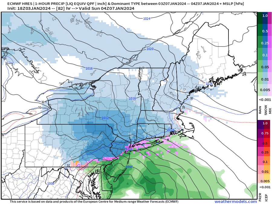
MAJOR WINTER STORM POSSIBLE – still on the table and we will not know fine details as models waffle back n forth from almost a foot plus to a meager 3-4” for the area. I mean NNJ and LHV.
Ingredients for a Major Winter Storm as I stated in my last post are still there, recap:
- Cold Air from a High Pressure anchored in SE Canada
- 50/50 Low Pressure system
- NAO Block over Greenland
- A Miller A storm track the comes up from the SE and slides off the Delmarva (Delaware, Maryland, Virginia) region (Ocean city Virginia) going over the 40/70 benchmark of warm gulf stream waters to fuel the storm
The four basic ingredients are on the table.
Time Frame: Moved up to Saturday afternoon/evening through Sunday morning maybe noonish
(Saturday night late through Sunday night/ Early AM Monday-OLD)
Snow amounts: from a few inches to over a foot for NNJ (still in play)
Rain Snow line look to be from Ocean County North (Monmouth and Middlesex CT. border)
We need one storm to help build the track and lay down the foundation for others to come.
Some Maps for your viewing pleasure but not etched in stone!!!
Money Shot – darker blues are overnight and that is heavy snowfall, pink is icy mix
Great Video!!
Updates to come and have a blessed, fruitful and joyous 2024 peeps!
Al Q


