- Winter Recap, Mr. Freeze tonight, Rainy chilly roller coaster
- Today Wintry Mix Storm, Big Snow Dawg Barking Thursday??
- Winter Storm #4 and #5, Earth’s Rumbling
- Ice Ice baby verifies, Saddle Up Cowboys and Girls – YEEHAW!! USAID Really?
- Thursday Winter Storm, Pattern is ABSOLUTLETY LOADED – SUPER BOWL STORM
- Clipper Verifies, Vanilla Ice Baby = Thursday Winter Storm
Storm Update
Related Articles
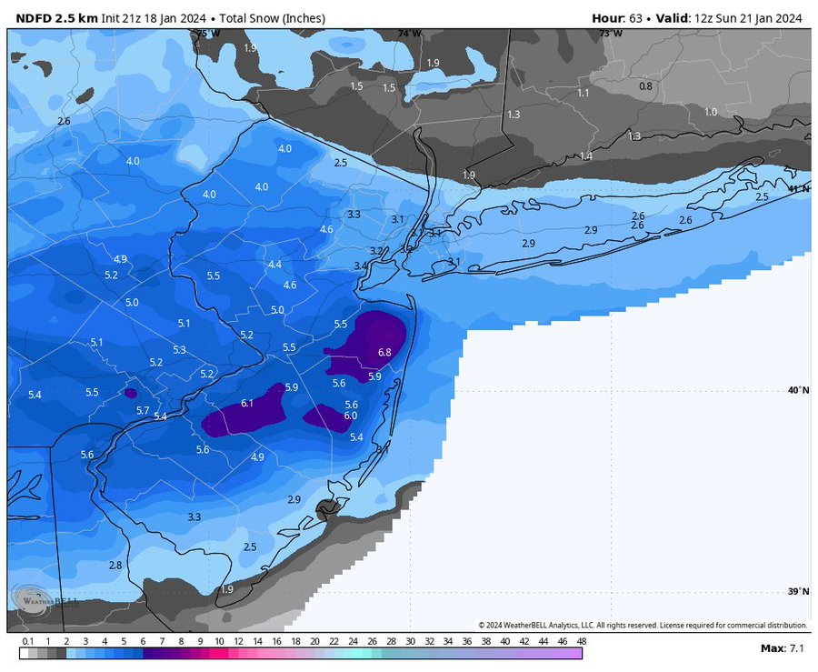
This is a tough call due to the raggedness of the system and when and where the heaviest snow bands will set up. Models have trended unfavorably for NNJ NYC Metro area and are more concentrated on CNJ and SNJ for highest snowfall 3-6/7″ range they are calling for. NYC still in the 2-3″ category Here is the latest Winter Weather Advisory from NWS:
School have a very tough in NNJ because IF this system takes a last-minute jog of 25 miles plus N then they are stuck with trying to get staff and students home in moderate to heavy snow of .5″-1.5″ per hour which would be an absolute nightmare = accidents galore, people being stuck etc. This would parallel but worse than the Nov 18th 2018 Thursday Storm but not after school DURING IT!!! After Tuesday’s storm they make the wrong call well ain’t no hiding but facing the fierce rage of the momma bears!! You KNOW they will hunt you down if their cubs get in an accident or hurt, what’s an early dismissal cost you……NOTHING!!!! This would be if such is done ..An ED (early dismissal) :

My confidence is low in this forecast due to another Low forming over the ocean off the Delmarva that will cause the dreaded subsidence to occur but where is the question? If this happens over NNJ then we’d see a C – maybe 1.5″ ala Tuesday’s Storm. If its further N then we may get a moderate storm of 3 – 6″
Kuz, Cuz’s in Freehold and Middletown, Mimi and McCann Land look to get the brunt of this storm along. Latest snow map from National Weather Service.
My Call:
1-3″ Snowfall
Less N – NW Bergen County about 1-1.5″
More (3″)Southern NNJ towards Union County
Timing: 7am ish start through 4PMish
Anti about this one folks and hope I am wrong and it comes 50 miles N and brings us 4-7″!!!
Next week we warm up for about 7 -8 days argghhh!!!
Have a good night and be careful tomorrow.
AL Q


