- Winter Recap, Mr. Freeze tonight, Rainy chilly roller coaster
- Today Wintry Mix Storm, Big Snow Dawg Barking Thursday??
- Winter Storm #4 and #5, Earth’s Rumbling
- Ice Ice baby verifies, Saddle Up Cowboys and Girls – YEEHAW!! USAID Really?
- Thursday Winter Storm, Pattern is ABSOLUTLETY LOADED – SUPER BOWL STORM
- Clipper Verifies, Vanilla Ice Baby = Thursday Winter Storm
STORM MODE – 3 for 3!!!
Related Articles
Nailed last nights storm said 3-6″ and ………. 4″ recorded here in NNJ Yonkers had 5″
WE ARE IN

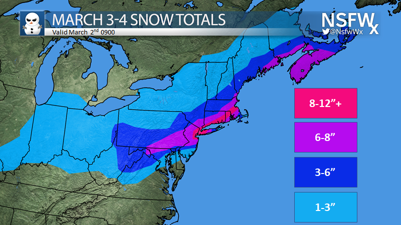
A SECS – yes pronounced SEX – means Strong East Coast Storm is shaping up. This Saturday storm is helping evolve this storm, the set up isn’t the best BUT it doesn’t matter Big Momma is making it happen.I said we could see anywhere from 3-12″ with this storm and the afternoon 12 Z suite has come in

NWS says this

My boyz say hells no this is more like it!

Frank the P

These would equal a MECS for some areas = Major East Coast Storm.
I AM STATING IT NOW – STATE OF EMERGENCY DECLARED BY THE BOY WHO CRIED WOLF NJ GOV. MURPHY AND
JUST FOR YOU PRINCESS AND MY WIFE ON HER 5? BIRTHDAY MONDAY


Sunday night Phone Calls in order
Start Time: 4-6PM ish
Heaviest Snow 8PM – 1AMish – rates of 1″ to 2.5″ per hour
End Time 2-4AMish
Don’t you nervous nillies fret of maybe we’ll have a delayed or second guess my hot streak if I hear such Debby wah wah I will offer this
Snowfall amounts – just look at the maps 6-12″
AM Commute – standstill
Then the cold arctic air comes in behind this storm.
Tuesday morning low’s – teens

Wednesday Morning Low

Thursday Morning Low

These may trend a few degrees lower with a snow pack of 8 -12″ on the ground .
This is the new month of…………………..Marbruary!!!! (march and February combined)
Don’t look know but Next weekend we may have another storm – 8-11th time frame go to more spring then possibly reload from teh 20th to teh end of teh month with 2 minor wintry events.
Update in the morning.
Al Q


