- Winter Recap, Mr. Freeze tonight, Rainy chilly roller coaster
- Today Wintry Mix Storm, Big Snow Dawg Barking Thursday??
- Winter Storm #4 and #5, Earth’s Rumbling
- Ice Ice baby verifies, Saddle Up Cowboys and Girls – YEEHAW!! USAID Really?
- Thursday Winter Storm, Pattern is ABSOLUTLETY LOADED – SUPER BOWL STORM
- Clipper Verifies, Vanilla Ice Baby = Thursday Winter Storm
Sound the Alarms Mr. Squidward!!!!!!!!!!! Puffers and Shakers intensify
Related Articles
https://youtu.be/adSgwaDMe1Q
I am sounding this ALARM for ALL FLA RESIDENTS IN HER PATH
https://youtu.be/1GDeeonselA
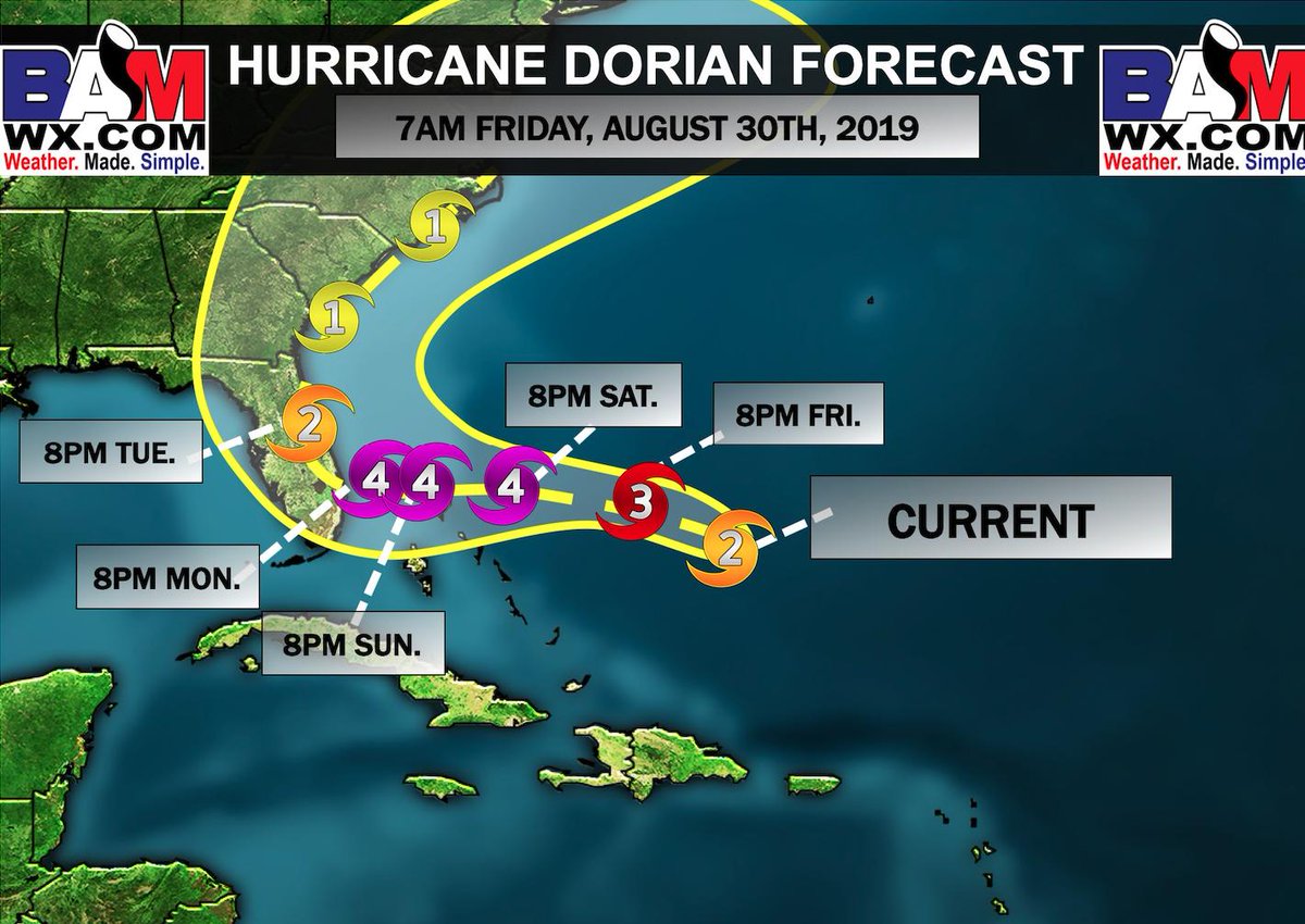
Dorian is cranking up and the prognosis, diagnosis and forecastosis (needed a another word to ryhm) is NG BIGLY for FLA residents in teh southern central part from West Palm Beach region up through the Daytona Beach region and then up the I 95 corridor probably about 20 miles inland or so.
She is packing a CAT wind field that extends about 35 miles out from her eye and yes she is gaining strength. There are warm bath waters in the Bahama Mamma region and this will feul her to gain strength and be a biag reaching the Major Hcane Scale level of a CAT 4. Here is the scale:


If you know anyone from Miami Beach North up through the Southern Ga flat water region tel them to start the preparations – food, gasoline – fill up their cars and extra gas cans, generators – rent now, propane for gas grilling, water, plywood to board up windows, put away any outdoor lawn furniture, batteries, flashlights, camping lanterns, and lastly fill up prescriptions if can be, OH and set your fridge to the coldest settings and freezer.
You do not have to be in the bulls eye to feel the great affects of these storms – hence in point Sandy, Matthew, Michael, Florence – flooding, winds are the greatest threats.
Power outages, infrastructure damage, bringing life in this day and time to a halt.
Timing: Sunday Night and making landfall Monday for Florida
Landfall Projection: Between West Palm Beach through Melbourne is the bulls eye region
Strength: Category 4
Her Path:
She looks to ride the coast and may just may get into the NYC Come next Thursday/Friday. I ‘ll keep an eye on this but the upper air patter with the big Bermuda High in the Atlantic will press her to stay towards the coast.
See the clouds blossoming- rising means she has been hitting the gym!
Sunrise Hurricane Dorian.
Dorian intensified overnight & will soon become a powerful major hurricane. pic.twitter.com/epX9W3r3Ie
— Dakota Smith (@weatherdak) August 30, 2019
US Virgin Islands Anguilla footage as a strong Trop Storm – Yikes:
Here is some storm footage of #Dorian as it passed through the US Virgin Islands! This storm is not one to mess with, please evacuate if ordered too! #hurricandorian @ChrisMartzWX @StormHour @HurricaneRiley5 @NHC_Atlantic @TropicalTracker @TropicalTidbits @StormBarretto @DCAreaWx pic.twitter.com/hS33x4MCyO
— Chase Koller | NOVA WX (@ChaseKollerWX) August 30, 2019
So peeps she is a DANGEROUS STORM – and let the folks know it FLA to get out of Dodge in the WPB through MELBOURNE REGION which looks to be where she’ll make landfall.
We may see her make an appearance come Thursday/Fridays time frame as a possible tropical storm. To what degree we won’t know but just keep an eye out for this.
You know Gov. Murphy will call a SOE (State of Emergency) and shut us down if she even comes within 50 miles of us!!!
She will be known and the Great Labor Day Hcane.
Puffer and Shakers
Coronal Hole I wrote about last time?? Anyone recall? No…………….write this 50 x each for HW:
I will read and listen to AL Q and what he has to say at all times!! LOL
Well, here is teh direct result massive Volcanic Eruptions in Italia and Russia hat will have an affect on our fall adn winter season by cooling us down:
Russia
SHIVELUCH (KAMCHATKA) VOLCANO ERUPTS TO 34,000 FEET (10.4 KM) — DIRECT COOLING EFFECT
On the back of Aug 24’s “did she, or didn’t she” eruption to 70,000 foot, strong explosive activity has been continuing at Shiveluch volcano over the past few days.https://t.co/7Pw3v8B0eS
— Electroverse (@Electroversenet) August 30, 2019
Italia:
Major eruption of Stromboli volcano, Italy yesterday, August 28th. Report via Met Hit. pic.twitter.com/fGXteawicV
— severe-weather.EU (@severeweatherEU) August 29, 2019
Pyroclastic flow from yesterday’s paroxysmal eruption of Stromboli volcano, Italy pushing over the sea! Report: Elena Schiera / Jurnal de Vreme pic.twitter.com/VrlozlEaEb
— severe-weather.EU (@severeweatherEU) August 29, 2019
Shakers:
M6.3 QUAKE HITS 284KM WNW OF BANDON, OREGON
“Grand Solar Minimum + Pole Shift.”https://t.co/eFuSkWoKsZ
— Electroverse (@Electroversenet) August 30, 2019
and tehre is another massive coronal hole opening up in our dimming sun:

Spotless Days
Current Stretch: 23 days
2019 total: 167 days (69%)
2018 total: 221 days (61%)
So what does this all mean – when teh geomagnetism of the sun and earth come into what is know as equatorial balance then all poop breaks looks with the earth geomagnetic relief valves = Volcanoes and EQ’s. More of these and stronger ones will be occurring – areas to watch out for are – wherever there is tension under teh surface and it wants to release this meaning any fault zone and dormant to active volcanoes – Washington State, California, Peru, Italia, Iceland, Asia, wherever these are basically.
Oh and isnt this weather delightful??? More to ocme and places in higher elevations of Ny State, NJ and Penn may see frost by Sept 15thish – no kidding!
Updates to come.
Al Q


