- Winter Recap, Mr. Freeze tonight, Rainy chilly roller coaster
- Today Wintry Mix Storm, Big Snow Dawg Barking Thursday??
- Winter Storm #4 and #5, Earth’s Rumbling
- Ice Ice baby verifies, Saddle Up Cowboys and Girls – YEEHAW!! USAID Really?
- Thursday Winter Storm, Pattern is ABSOLUTLETY LOADED – SUPER BOWL STORM
- Clipper Verifies, Vanilla Ice Baby = Thursday Winter Storm
RECORDS BROKEN. SNOWWWWWWWWW, THEN MORE RECORD COLD!!
Related Articles
Records were broken last night and this morning with this appetizer wave of cold?
Records broken
NYC, New Brunswick, NJ to name a couple. More will be published once they get going this Saturday.
Update, Islip Long Island, Baltimore, M. also just reported breaking records – WAKE UP AND GET US REPORTS!!!
Appetizer:

Yes the appetizer cause the next cold blast is gonna feel like JANUARY!!
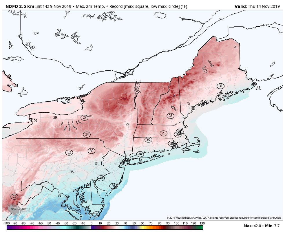
Wednesday morning lows

Tursday Morning Low
ARCTIC COLD FRONT is poised to sweep across the south on Tuesday. 🥶🌡
Wednesday morning looks brutally cold, with temps plunging into the 20s! Definitely will need to protect those pipes, plants, & pets! ❄️🐶
📸: @RyanMaue & @weathermodels_ pic.twitter.com/LSz6S6n6rP
— Dylan Federico (@DylanFedericoWX) November 9, 2019
Tuesday morning/afternoon
What: Rain to ice (sleet) then to snow
Accumulations: Some minor for NNJ – coating to an 1″ as you move further N& W on colder surfaces – car tops, grassy surfaces
N&W – 20-25 miles outside the city – Western Passaic, Western Bergen, Northern Rockland, Northern Westchester and Southern Orange counties see 1-3″, as you move to Northern Orange and Putnam you go 2-4″.
Then the brutal cold for this time of year rushes in.
If you dont have the flannel sheets on ye bed, thermal undies, winter jacket and hat, gloves ready, firewood split and stores inside and snow shovel sharpened and snow blower gassed up for those further away (N&W) then……………………
MAPS

NAM is good for snow lovers. Flakes for nearly everyone. This system is dealing with a better more reliable source of cold air. pic.twitter.com/RBcdWTvimP
— NortheastWeatherWx (@NEWeatherWx) November 9, 2019

OH and Thursday Night’s clipper brings more snow flurries and showers WOOP WOOP!

Lastly big Volcano Explosion in Japan
Explosive activity continues. Volcanic Ash Advisory Center (VAAC) Tokyo warned about a volcanic ash plume that rose up to estimated 22000 ft (6700 m) altitude
Japan’s Sakurajima volcano erupts in miles-high plume of ash https://t.co/pTF3PIWFzk #grandsolar
— Grand Solar Minimum (@grand_solar) November 9, 2019
LR outlook for Nov, we get some moderating temps adn the cold looks to come back and models are suggesting from late November 21stish through the middle of December
Updates to come.
AL Q – “Al”stradamus


