- Winter Recap, Mr. Freeze tonight, Rainy chilly roller coaster
- Today Wintry Mix Storm, Big Snow Dawg Barking Thursday??
- Winter Storm #4 and #5, Earth’s Rumbling
- Ice Ice baby verifies, Saddle Up Cowboys and Girls – YEEHAW!! USAID Really?
- Thursday Winter Storm, Pattern is ABSOLUTLETY LOADED – SUPER BOWL STORM
- Clipper Verifies, Vanilla Ice Baby = Thursday Winter Storm
Monte Python, Arctic Blast
Related Articles
Arctic front came through and we had two snow squalls for about 15 minutes each and sadly no accumulation though .5-1″ fell across NNJ. From when I posted on Friday it was delayed until 1PM instead of 10/11AM when the temp was mid 30’s, the snow would have stuck with teh Dew Points. It has been a true winter day with very windy conditions and cold temps and wind chills. That shall continue the rest of this week. It’s winter no complaining peeps if you do not like then….MOVE!!! to a warmer climate.
Monte Python..??
What is this in reference to you might ask? Good question.
Well the classic east coast storm was on, then canceled and now it back on again so…IT’S NOT DEAD YET. Well anymore I should say.
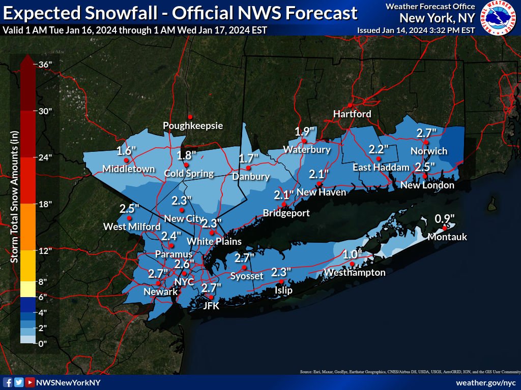
We went from what looked like a 4-8″ possibly 6-12″ storm to flurries to now trending strong in the 2-4″ range that may have perfect timing that will bring smiles and joy to every school girl and boy, including all teachers and staff, faces!! And why? Possibly leaning on Delayed Openings to…. Maybe just maybe cancellations if it keeps trending.
Timing is everything – time and space peeps is what it is all about. Think about this and you’ll be amazed, meeting your friend, wife/hubby, celebrity, accidents etc. etc.
We now have this:
Close up on NYC, NNJ, CNJ, LI, LHV region – 2-4″ plus from noon today

Tonight, runs have increased the snowfall amounts. TREND IS OUR FRIEND and it’s been trending stronger and more snowfall with each run!! That what we want to see peeps not the other way. Can we keep it going? I think so but that maybe my snow weenie goggles on LOL. That’s why I am the SNOW KING!!
From my man Will C on twitter – great non pro met! From 9AM this morning – nailing it
Folks, if this occurs then delays are a lock and many will close in NNJ, LHV and the HV for sure. on Tuesday. The old MLK day storm!
Frist snowstorms are teh worst, people forget how to drive and with arctic temps in the 20’s it will stick right away. The snow ratios will not be normal 10:1 but more like 15:1 maybe 20:1 in teh cold arctic air, light and fluffy snow.

Timing: starting around 3 – 4AM from CNJ to NNJ
Ending: 2 – 4PM from South to North
Snow Totals may increase to 3-5″ from 2-4″ if this trend continues!!
Arctic Blast
Lows Tonight

Wind Chills

Tues Night Wind Chills

Wednesday morning 6-7AM

Possible snowstorm Thursday night through Friday night if all comes together.
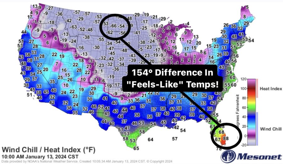
Check this out from the Arctic Blast in the heartland of the USA.
Updates to come.
AL Q


